- Collections
Digital Collection


New Releases
- Calendar
- Programs
- News
- Research
- Search Catalog
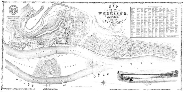
A new inventory of the Map Collection at the Ohio County Public Library is now available. The Archives and Special Collections department holds an extensive variety of maps of Wheeling, the surrounding Ohio Valley, and West Virginia dating from 1821 to 1990.
Early notable maps of the Wheeling area include the 1853 Map of the City of Wheeling and Suburbs, Ohio County, Virginia (Manfred & Simpson) and the 1870 Map of the City of Wheeling, South Wheeling and La Grange, West Virginia (Jas. Gilchrist, C.E. & F.W. Beers & Co.). Another gem in the collection is an 1862 map of Pennsylvania, Virginia, Delaware and Maryland, depicting railroads, roads, towns and rivers in rich color detail. Later maps of Wheeling also depict surrounding areas including Glen Dale, Warwood, Elm Grove, and Martins Ferry and Bridgeport, OH.
The library holds both photocopies and original maps in this collection and the inventory includes this designation.
➤ View the Map Collection Inventory.
To view any of these maps, please call 304-232-0244 or send an email via our Ask an Archivist form to make an appointment. Many of these maps are fragile and unique; patrons can view them in the Wheeling Room at the library.
52 16th Street
Wheeling WV 26003
Phone: 304-232-0244
Online Catalog
Map & Directions
E-mail Us
Follow us on Social Media:
OCPL appreciates the generosity of patrons in donating books, historical materials, and other library materials. Due to the number of items donated, limited staff, and limited space to house materials, the OCPL must restrict the donations accepted. We welcome donations and encourage reading our Donation Policies before donating:
Book Donations Historical Materials Donations
Partners:
![]()
![]()
© Copyright 2026 Ohio County Public Library. All Rights Reserved. Website design by TSG. Powered by SmartSite.biz.